Climate & environment
Building corporate and investor resilience to climate and environmental risks
How we help
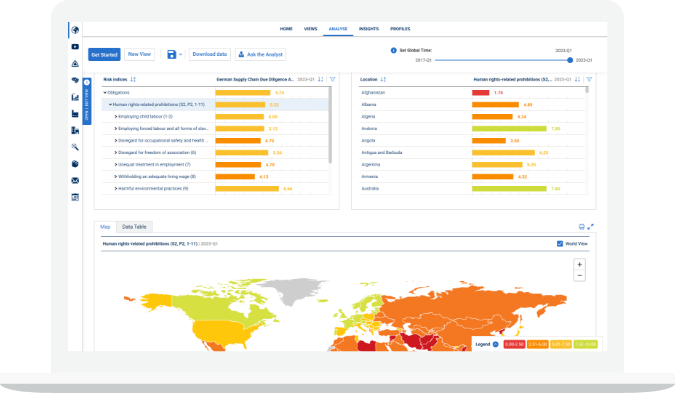
Map
Map global exposure to climate change, biodiversity, water issues, deforestation, natural hazards, and regulatory challenges down to the asset-level
Forecast
Forecast risk and develop long term strategies with a suite of the most up-to-date climate data, covering a range of scenarios and timeframes
Plan
Develop actionable risk mitigation plans that help focus resources where they are needed most to build resilience
Assess
Assess exposure and dependencies to natural capital across the value chain from direct operations down to the commodity-level
Align
Align disclosures with industry best-practice benchmarks like the TCFD and the TNFD
Navigate
Navigate the latest policy, regulatory and reputational impacts arising from a rapidly shifting landscape of climate and environmental issues


FAQs
-
How do you help organisations align with the TCFD recommendations?
Our experts have a deep understanding of the growing physical impacts of climate change, rapidly changing regulatory environments and shifting stakeholder expectations. Together with our proprietary data, our consultants can help you: assess climate risks and opportunities; develop and implement your climate change strategy; and transparently report to key external audiences.
-
What can I do to improve our environmental reporting and fulfil disclosure requirements?
By drawing on the knowledge and experience of our experts, you will be able to pinpoint exactly how to improve your compliance with and reporting on GRI Standards, CDP, SASB, TCFD, UN SDGs and the EU Non-Financial Reporting Directive
-
Can you help my company advance its corporate water stewardship strategy?
By screening operations and suppliers against our water risk data, you will be able to identify hotpots inside and outside the fenceline, and our consultants will help you embed sustainable water management practices
-
How do I stay ahead of developing environmental regulatory and reputational issues?
Our innovative horizon-scanning analysis, subject matter expertise and a wide-ranging portfolio of risk analytics will enable you to obtain first-mover advantage related to regulatory change, policy shifts and emerging reputational issues
-
Do you build interactive risk management platforms tailored to an organisation’s precise needs?
Our consultants can develop a customised risk management solution for you by combining your corporate data on global operations and suppliers with our own risk analytics, and thereby provide complete transparency on your exposure to key environmental issues
Get in touch today to discuss how we can help you with our Climate & environment solutions…
Related content
Solutions
Environmental Risk Dataset
Geospatial insights into nature-related risks to resilience and sustainability